What Is A Title Plan? Deed Plan Vs Title Plan; Land Registry Title Plan Example
What Is A Title Plan? Deed Plan Vs Title Plan; Land Registry Title Plan Example
What Is A Title Plan?
A title plan is a map issued by HM Land Registry that accompanies a title register, showing the boundaries and extent of the legal title to a property. It is based on Ordnance Survey mapping and uses a red edge to depict the boundary of the registered land.
The purpose of the title plan is to support the written description of the property in the register by providing a graphical representation.
It shows general rather than precise boundaries. References in different colors are sometimes used to identify rights, restrictions, or exclusions affecting parts of the land.
How To Read A Title Plan
Here are some key points on how to read a title plan from the GOV.UK guide:
- The title number identifies the registered property.
- It will have a map reference showing the area from the Ordnance Survey map used.
- There will be an arrow pointing north.
- Boundaries are shown as black lines – these may represent walls, fences, hedges etc.
- The land within the title is edged red. This follows the inside of the physical boundaries.
- Other colors like blue, yellow and brown show rights of way over the land. Pink shows exclusions.
- References relate colored areas on the plan to entries in the property register, like easements.
- The date and time shows when the plan was extracted from the Land Registry records.
Some other useful tips:
- Boundaries are general not precise.
- Look for notes explaining symbols or colors used.
- Compare the plan to the written register entry for full details.
- Plans can’t be relied on for exact boundary locations.
- Get a professional boundary survey done if you need to pinpoint boundary lines.
Deed Plan Vs Title Plan
Deed plans are historic private documents while title plans are official Land Registry plans showing legal boundaries for registered titles. Title plans take precedence where land is registered.
💥🎁 Christmas & Year-End Deals On Amazon !
Don't miss out on the best discounts and top-rated products available right now!
🛒 Shop Now and Save Big Today!*As an Amazon Associate, I earn from qualifying purchases.
Here is a summary of the key differences between deed plans and title plans:
- Deed plans are historical plans attached to property deeds, showing boundaries at a past point in time.
- Title plans are issued by HM Land Registry when registering a title, showing current boundaries.
- Deed plans are not official or conclusive. They may be indicative but imprecise.
- Title plans legally define the boundaries and extent of the registered land.
- Deed plans are created by private surveyors at any time. Title plans use OS maps and Land Registry standards.
- Boundaries may have changed from those on old deed plans when a title is later registered.
- Title plans supersede deed plans. Any variations arise where boundaries have moved.
- Deed plans can provide evidence helping to establish boundaries.
- But title plans take precedence as the definitive plan for registered land.
- Unregistered land continues to rely on old deed plans as evidence of boundaries.
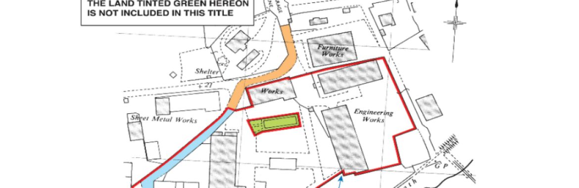
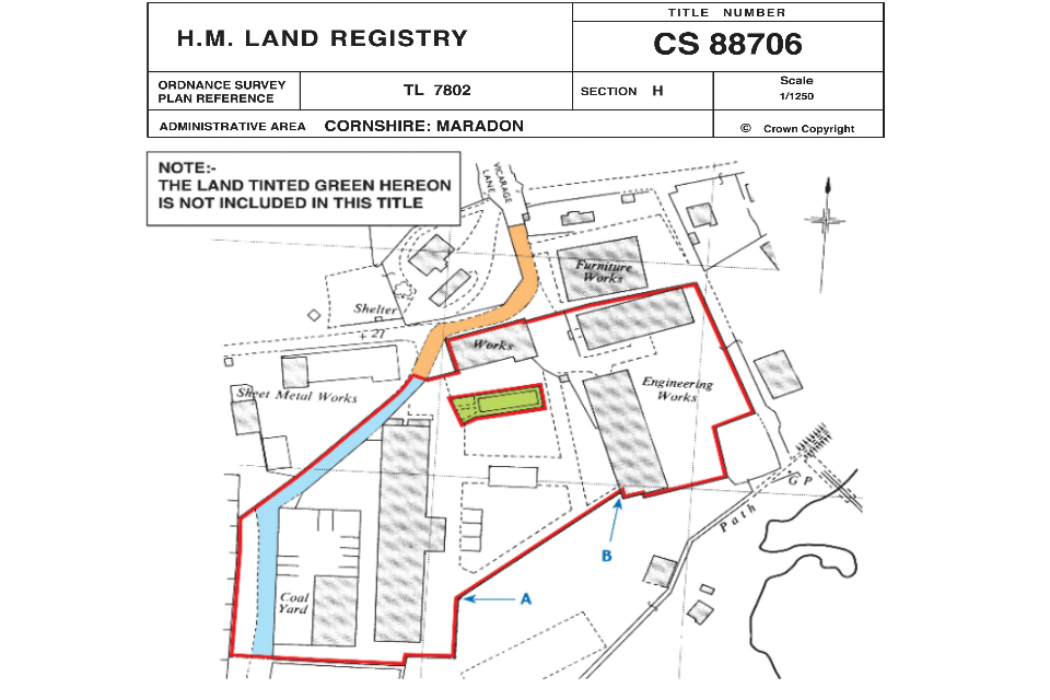
Land Registry Title Plan Example
A land registry title plan is a graphical representation of the boundaries and extent of a property, issued by HM Land Registry when land is registered. Title plans are based on Ordnance Survey mapping and use a red outline to depict the legal boundaries.
Example title plans can be viewed on the Land Registry website by searching a property address. These show features like the red boundary line, title number, orientation arrow, references in other colors, and north point. Boundaries are general not precise.
Example title plans help convey how land ownership is represented visually in Land Registry records. They should be viewed alongside the title register for full details.

This allows you to search for a property by address and view its title plan.
💥🎁 Christmas & Year-End Deals On Amazon !
Don't miss out on the best discounts and top-rated products available right now!
🛒 Shop Now and Save Big Today!*As an Amazon Associate, I earn from qualifying purchases.
Some things to note about the example title plans:
- They show the outlined boundaries of the property in red.
- References in other colors depict rights, restrictions, easements etc.
- They contain a title number, orientation arrow, scale, area measurement.
- They are based on Ordnance Survey maps.
- Boundaries are general not precise.
- Notes explain symbols, colors and some references.
- Must be read alongside the title register for full details.
- Can order copies for £3 if you want the latest up-to-date plan.
Viewing examples helps understand how title plans graphically depict property extent and boundaries as part of the Land Registry records.